
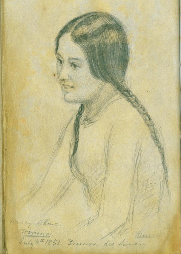
A Dakota woman named Winona who attended the 1851 Traverse des Sioux treaty.
Clay County Histories
Markus Krueger | Program Director HCSCC
It’s a common question that has killed a lot of people. Who is the rightful owner of this land, ask Ukrainians and Russians, Palestinians and Israelis. I personally think people move around too much to perpetually tie them to any particular piece of dirt. The hometown of my German ancestors is in Poland now. Scotland has not always been the land of Scots. I reject the question if it is asked in order to tell someone they do not belong where they live.
But if you are curious about who lived in a certain place at a certain time, that’s a different matter that I love to talk about. Before the dirt under my house was called Moorhead, Minnesota, USA, it was the borderland between the Dakota (aka Sioux), Ojibwe (aka Chippewa) and Métis (aka Michif) peoples. Treaties give us an idea of who claimed ownership of the land, but like everything in history, it was more complicated than that.
This year marks the 200th anniversary of the Treaty of Prairie du Chien. In 1825, Indigenous leaders from around the region met in a place we now call Wisconsin to hash out the borders of their realms. Those particular leaders, in that place, on that day, said that around here, Ojibwe country starts north of the Buffalo River and Sheyenne River, and Dakota country begins on the southern banks of those rivers. Both rivers flow into the Red River just a bit north of Moorhead. This border was fuzzy and contested. Ojibwe and Dakota people lived and worked on either side of this border, but in the 1850s, when the USA was looking to buy more land, these 1825 treaty borders were used to sort out who owned the land they wanted to buy.
In 1851, US negotiators met with leaders of the Wahpeton Dakota and Sisseton Dakota at the Treaty of Traverse des Sioux to purchase most of the land these bands claimed on the Minnesota side of the Red River. The Yankonai Nakota, a related band who also called this land home, was not invited to the treaty, so they lost this land without compensation. This treaty brought the southwestern half of Clay County into the USA.
When talking about Native American history, I have often told classes of school kids visiting our museum that, since Moorhead is south of the Buffalo River, they are sitting in the land of the Sisseton and Wahpeton Dakota. But whenever I do so, I feel the ghost of Ayabe-way-we-tung, a chief of the Pembina Ojibwe whose English name is Little Shell, replying “Like heck it is! This is Ojibwe land!” Four Ojibwe bands also claimed some ownership of this land: the Mississippi Ojibwe (centered at Gull Lake near modern-day Brainerd), the Pillager Ojibwe (Leech Lake/Walker), the Red Lake Ojibwe, and the Pembina Ojibwe (which mostly turned into the Turtle Mountain Band of Chippewa. “Chippewa” is an older spelling of “Ojibwe”).
The northeastern half of Clay County that lies north of the Buffalo River came into the USA in the Treaty of Washington in 1855 with the Pillager and Mississippi Ojibwe. The Red Lake and Pembina Ojibwe were not invited to that treaty, but their leaders sold much of their remaining MN and ND land to the USA in the Old Crossing Treaty of 1863.
In the 1870 US census, most residents of Clay County were Métis, an Indigenous Red River Valley culture of mixed Ojibwe, French, Cree, British, and Assiniboine ancestry. In the 1700s, the Cheyenne lived around here (hence the Sheyenne River). People lived here before that, but we don’t know what locals called themselves back then.